Our End to End Larapinta Trail trek is a 16 day wilderness adventure totally immersing you in the country, and allowing the time and space to fully appreciate and understand this spectacular place.
The itinerary has been designed so we walk the entire length of the Larapinta Trail, all 223 kilometres, along with some extra special highlights not officially on the trail. You will experience all the trail has to offer, from high ridgelines to sheltered gorges, open savannah country to magnificent mountains, dry and flowing rivers, and the best examples of the West MacDonnell’s vegetation and fauna. All this along with the support of Trek Larapinta’s experienced and knowledgeable guides, and returning to the comfort of your supported camp each night. On each section you will be tested and rewarded until the final section: truly the trip of a lifetime.
As a keen bushwalker, the 16 day End to End Larapinta Trail trek will delight those looking for a true wilderness experience. Expecting to walk between 5 and 12 hours per day along varying difficulty of terrain including some very rugged terrain, the trek will challenge the most experienced of bushwalkers.
For each day’s hike on this rugged world class track, you carry just a day pack. We create these trips to be an informative experience as well as a walk through the unique terrain, as we seek to share our knowledge of the place and provide all you need to have an active yet comfortable holiday. You walk with a guide for the day’s trek, with the support guide collecting and transferring you to camp each day, where you can relax while Trek Larapinta caters for your needs.
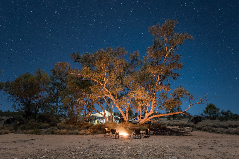
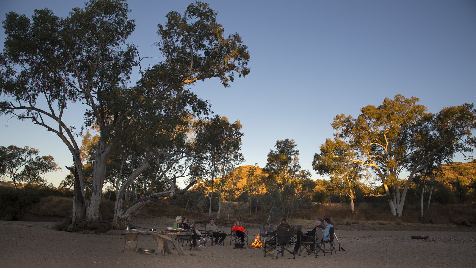
Being a small, boutique business, we remain keenly aware that we rely on the health of our environment. It sustains us and we, in turn, seek to sustain it. On the 16 day trek your campsites will vary throughout the trip; for the first seven nights you will be in different remote bush locations, while on the second half of the trail we use two base camps transferring short distances each day on the trail. Our camp sites at Serpentine chalet and in the Ormiston Gorge region are used due to their beautiful bush settings and centralised locations between a number of sections which minimises transfer time. We seek to tend our camps as best we can with minimal impact practices and share these ways with you.
Itinerary Summary
Day 1 : Pick up Alice Springs, section 1 – Telegraph Station to Wallaby Gap | 13.5kms Day 2 : Section 1 – Wallaby Gap to Simpsons Gap, visit Alice Springs Desert Park | 10.5kms Day 3 : Section 2 – Simpsons Gap to Jay Creek | 25kms Day 4 : Section 3 – Jay Creek to Standley Chasm | 13kms Day 5 : Section 4 – Standley Chasm to Birthday Waterhole | 17kms Day 6 : Section 5 – Birthday Waterhole to Hugh Gorge | 17kms Day 7 : Section 6 – Hugh Gorge to Rocky Gully | 16kms Day 8 : Section 6 – Rocky Gully to Ellery Creek | 15kms Day 9 : Section 7 – Ellery Creek to Serpentine Gorge | 14kms Day 10 : Section 8 – Serpentine Gorge to Serpentine Chalet | 15kms Day 11 : Section 9 – Serpentine Chalet to Ormiston Gorge | 29kms Day 12 : Section 10 – Ormiston Gorge to Glen Helen/Finke River | 12kms Day 13 : Section 11 – Finke River to Rocky Bar Gap | 15kms Day 14 : Section 11 – Rocky Bar Gap to Redbank Gorge | 12kms Day 15 : Section 12 – Redbank Gorge to Mt Sonder (return) | 16kms Day 16 : Ormiston Pound/Gorge walk, return to Alice Springs | 8kms
What’s included
Travelling with us, you know you’re coming with a boutique business that specialises in the Larapinta Trail. The experience of being in this ancient landscape can be powerful and refreshing. By offering fully-supported camping and interpretive guiding, Trek Larapinta aims to facilitate this experience for you. All the organisation, transport, food preparation, camping and catering equipment and other logistics are taken care of for you, so you can connect with this landscape in a calm, relaxed way and get the most out of your holiday in this amazing part of Australia.
All camping equipment including sleeping bag, swag, pillow, bed linen and top of the range tent.
All catering equipment.
15 breakfasts, 16 lunches, 15 dinners.
All delicious snacks on the trail.
Hotel pick up and drop off.
Transportation provided in commercially registered, expertly maintained tour vehicles.
All camping, traditional owner and national park fees.
Entry to the Alice Springs Desert Park.
Group first aid and emergency communication facilities.
2 Trek Larapinta professional wilderness guides.
Travelling with a culturally and environmentally responsible business.
Small group with a maximum of 8 participants.
Tours do not include pre or post trip airfares or accommodation.
Detailed maps of the Larapinta Trail are also available for purchase.
Notes to consider
The 16 day End to End Larapinta Trail trek requires a high level of bushwalking/walking and general fitness. As the Larapinta Trail becomes more popular the perception of its difficulty decreases. This however is not the case. The trail remains unrelentingly rocky and hard underfoot and weather extremes can be experienced at any time of the year, so the more prepared you are the more you will enjoy the experience.
Days vary between 5 and 12 hours of easy to moderate to very challenging walking, depending on the section. The climb up and down Mt Sonder is a challenging 16km return with a 750m rise in elevation. Section 9 is a very challenging day covering a rocky distance of 29km, including some steep ascents and descents.
If you engage in at least one to two hours of aerobic activity (this might include walking, cycling, swimming etc) three to four times a week during the three months prior to your trip, you should find yourself fit enough to enjoy your days’ activities. Longer walks on uneven bush tracks with your day pack, including some ascents/descents (if you can find them) will help you prepare your body for the full days on the trail.
Further information about preparation can be found at Trek Gradings and our FAQ section .
After collecting you in Alice Springs from your hotel at 7.30am we begin our adventure on the Larapinta Trail at the historic Alice Springs Telegraph Station, the official start of this incredible wilderness journey. Our first morning is spent following the old telegraph line through the ancient granite rock country, north of Alice Springs. We cross the Ghan Railway, trek through dry riverbeds and along high escarpments to the top of Euro Ridge, where we enjoy a delicious fresh lunch overlooking the Alice Valley and the vast MacDonnell Ranges. The trail heads downhill to Wallaby Gap where hopefully we encounter some of its well hidden inhabitants. Our camp, a refreshing drink and a comfy chair aren’t too far away. The afternoon is spent relaxing, spotting the abundant birdlife that lives around camp, setting up a tent and enjoying our first dinner together. As the evening light changes over the surrounding ranges we recount our first day’s highlights and discuss tomorrow’s walk, before going to bed under a ceiling of millions of stars. Each morning begins with a big healthy breakfast, freshly brewed coffee/tea before heading back onto the trail.
13.5km/6hr walk
Meals: Lunch, Dinner
Day 2: Section 1
We spend our second day completing section 1 of the Larapinta Trail, taking us past the Scorpion Pools, through large stands of Mulga woodland and many other flowering plants; before climbing up into Hat Hill Saddle. The views from here reveal our first close vistas of the rugged Chewings Range, a mountain range that we get to know very well in the coming days. After finishing our walk at the stunning Simpsons Gap, we visit the award winning Alice Springs Desert Park to learn more about the local flora and fauna of this magnificent region. Camp tonight is at Wallaby Gap. Splitting section 1 of the Larapinta Trail in half and making two easier days gives us a chance to get our legs warmed up, become more familiar with the surrounding environment, and eases us into the trail.
10.5km/4hr walk
Meals: Breakfast, Lunch, Dinner
Day 3: Section 2
Setting off early from Simpsons Gap, we enjoy a long day over easy to moderate terrain taking us to the beautiful gorges of Bond and Spring Gap. We arrive at our camp tonight on Jay Creek later in the day. The feeling changes out here as we start to enter more remote country; there will be a certain stillness as we ease into the splendid isolation. The next three days are regarded by most to be some of the most spectacular and rugged walking on the Larapinta Trail, indeed in the world.
25km/9hr walk
Meals: Breakfast, Lunch, Dinner
Day 4: Section 3
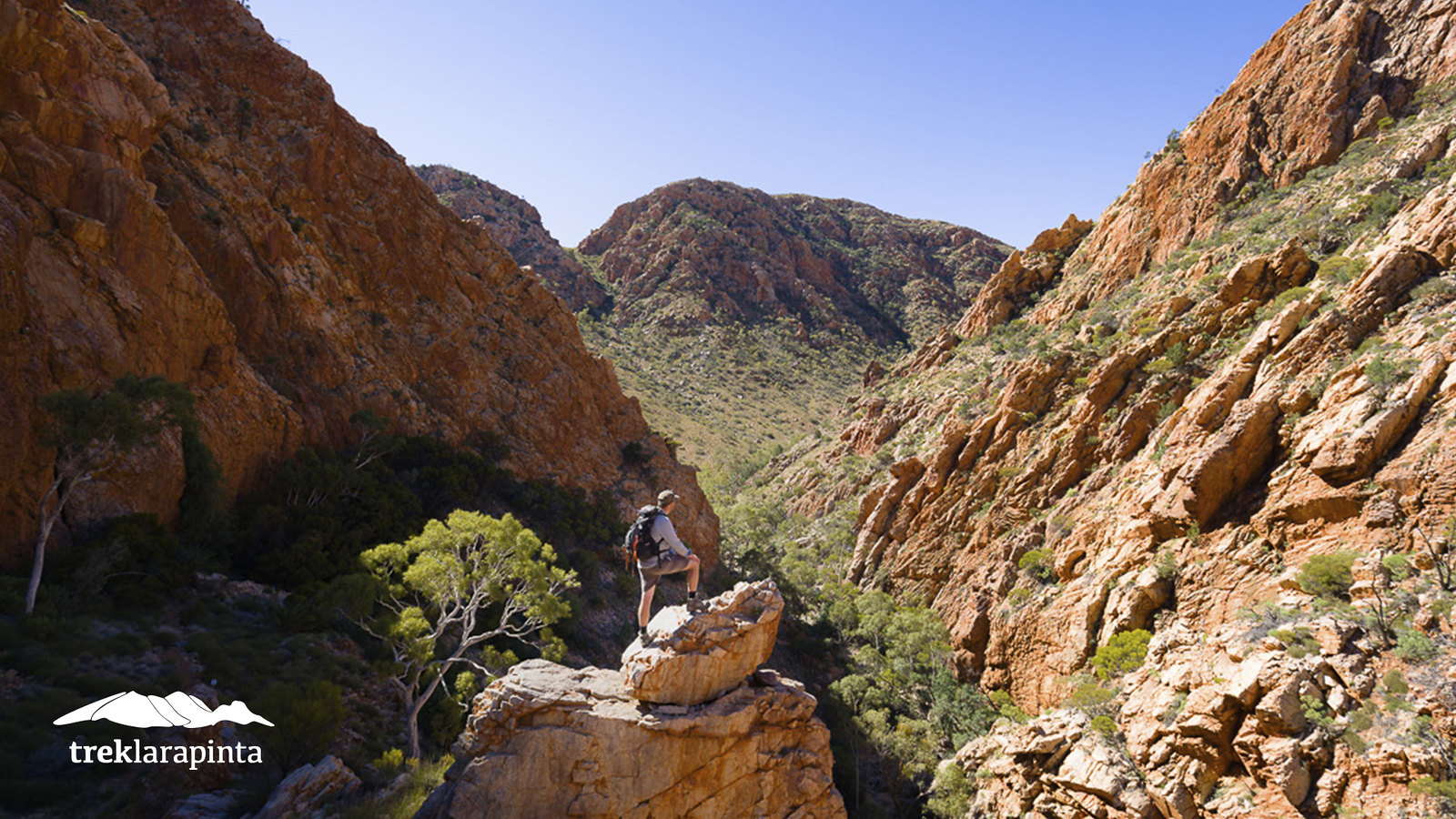
An early start walking along the cool river bed of Jay Creek sees us setting off on Section 3, one of the trails most spectacular sections and one of our favourites! Today’s walk is considered to be one of the most challenging yet scenically rewarding sections of the Larapinta Trail. Made up of deep sheltered gorges, exposed saddles and steep climbs, we are dwarfed by massive quartzite ridges and treated to magnificent views of the surrounding Chewings Range. We finish the day passing through the iconic Standley Chasm on the way to our camp nearby. Around the camp fire tonight we enjoy another delicious meal prepared by your guides.
13km/8hr walk
Meals: Breakfast, Lunch, Dinner
Day 5: Section 4
Climbing up an open valley in the cool morning air, surrounded by giant orange quartzite peaks, is just a sign of things to come on this very scenic section of the Larapinta Trail. As we rise above the landscape along the high ridge of Brinkley Bluff, we become some of the privileged few to behold this truly stunning view. After a well earned rest and a bite to eat, we begin our long steep descent down the mountain past Rocky Cleft to Stuarts Pass. The last hour sees us walking in the footsteps of the man after whom the pass is named, enjoying a relatively easy section, providing a welcome respite after the rough terrain we have just hiked. Camp tonight is at the remote and secluded Birthday Waterhole.
17km/9hr walk
Meals: Breakfast, Lunch, Dinner
Day 6: Section 5
We start our walk this morning climbing through the spectacular Spencer Gorge, with its narrow red walls and rare plant life it’s a place we could spend hours, but today is one of the hardest sections on the trail, so after a quick stop we push on. As we keep rising, our view back down the valley and the surrounding mountains is awesome and it’s about to get even better. Arriving at the top of Razor Back Ridge we are treated to what our guides say is the ultimate view. After balancing our way along the ridge, our journey continues up Linear Valley to the majestic Hugh Gorge, where we will find our camp for tonight.
17km/9hr walk
Meals: Breakfast, Lunch, Dinner
Day 7 & 8: Section 6
We spend two days completing section 6 of the trail earning a few well deserved easier days as we cross the Alice Valley. Slowly moving away from the Chewings Range, we lose sight of familiar ground and a new landscape appears as we pass through the Heavitree Range, taking our first few footsteps on younger earth. The first night’s camp is at Rocky Gully with the second night spent at Serpentine Chalet bush camp.
Day 7 16km/7hr walk
Day 8 15km/6hr walk
Meals: Breakfast, Lunch, Dinner
Day 9: Section 7
Our journey continues today from Ellery Creek as we walk west along section 7, trekking beside the low dolomite ridges to Serpentine Gorge. Camp tonight is at Serpentine Chalet bush camp and we have the opportunity to explore the remnants of a pioneer tourism venture that was a long way ahead of its time.
14km/6hr walk
Meals: Breakfast, Lunch, Dinner
Day 10: Section 8
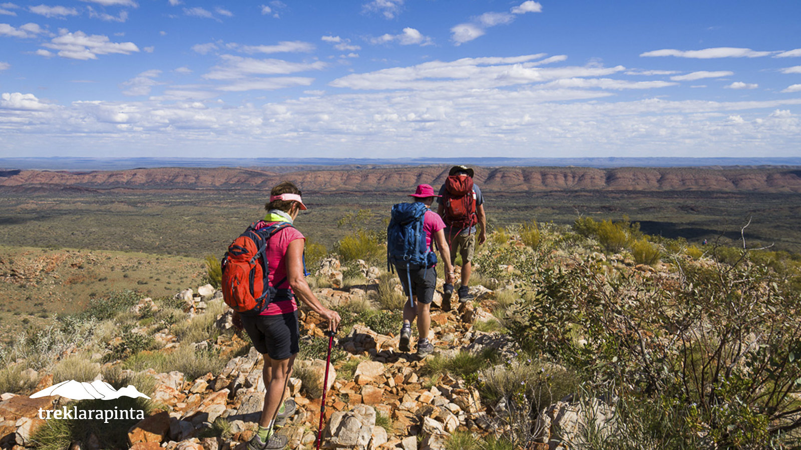
Today sees us high up on the Heavitree Range, walking along one of the Larapinta’s classic sections, slowly heading towards Counts Point. One of the highlights along the trail, (so good that Qantas helicopted a children’s choir up here!), Counts Point with its stunning views and incredible sense of space is a sensational place for a snack and some quiet, deep breathing. Camp tonight is at Serpentine Chalet.
15km/7hr walk
Meals: Breakfast, Lunch, Dinner
Day 11:
Our eleventh day sets off along section 9, the longest section on the trail. Although hard, it is a beautiful section of the Larapinta which meanders through long valleys and up onto the high ridgelines opposite Mt Giles, offering us magnificent views west towards Mt Sonder. Following some rock hopping through Inarlanga pass the trail winds along a creek bed lined with inland Tea Tree and swings west into open country, before crossing three saddles on the way to Waterfall Gorge. In the quiet of the gorge we take some time to reflect and appreciate this special place for the Western Arrernte people. Following a steep zig-zagging path out of the gorge we summit The Lookout at an altitude of 1,088 metres, a magnificent panoramic vista opens out in front of us – stunning views with all the highest peaks in the West MacDonnell Ranges on show. Descending through the foothills, the trail cuts through rolling limestone hills dotted with Red Mallees and Desert Bloodwood Trees. We camp tonight in the Ormiston Gorge
or Finke River region.
29km/10-12hr walk
Meals: Breakfast, Lunch, Dinner
Day 12: Section 10
Today we walk section 10 of the Larapinta Trail, taking us from Ormiston Gorge to the historic Glen Helen homestead, situated on the mighty Finke River. The Finke is one of the oldest watercourses on our planet and is dotted with massive River Red Gums and is home to a splendid array of birdlife. Wildflowers often bloom through this section. At the end of the day we have the
chance to go for a swim in Glen Helen Gorge or the Finke River. We sleep tonight in the Ormiston Gorge or Finke River region.
12km/5hr walk
Meals: Breakfast, Lunch, Dinner
Day 13 & 14: Section 11
Once we set off from the Finke River, we really start to feel our progression towards Mt Sonder, with each kilometre walked revealing closer views of this elegant desert peak. The wild flowers on this section are particularly beautiful and the giant River Red Gums stand tall and strong. Our second to last climb on the official trail is the well named Hill Top Lookout. From here we can fully appreciate our final challenge and look back towards where our journey began.
Day 13 15km/7hr walk
Day 14 12km/4hr walk
Meals: Breakfast, Lunch, Dinner
Day 15: Section 12
The final day of the official trail through the mountains of Central Australia culminates in the challenging ascent to the summit of Mt Sonder, and the end of the Larapinta Trail. As we approach the top of our final climb the sense of achievement hits home, a vast 360 degree panorama of Central Australia surrounds us, rugged and yet from up here so very peaceful. Remote desert peaks stretch as far as the eye can see. The view north looks 100km into the Tanami Desert, to the east we see the majority of the Western MacDonnell Ranges and a large part of what we have walked in the past 15 days. To the south is the meteor crater of Gosse Bluff and to the west Mount Zeil, the Northern Territory’s highest mountain. It is the only way to finish such an amazing journey and is something remembered for a lifetime. Return to camp for our final night together, with time in the afternoon to rest in surrounds or visit Glen Helen Gorge.
16km/7hr walk
Meals: Breakfast, Lunch, Dinner
Day 16: Ormiston Pound
While not part of the Larapinta Trail, the Ormiston Pound loop walk is a must do side-trip for anyone that comes to Central Australia, and a spectacular and relaxing way to finish an incredible journey. It takes us up to the high escarpment overlooking this natural impoundment, before descending into the pound itself. We finish the loop by walking down the gorgeous Ormiston Gorge. After lunch we head back to Alice Springs, where we drop you off at your hotel around 4pm.
An epic journey – a lifetime of memories
8km/4hr walk
Meals: Breakfast, Lunch
IMPORTANT NOTES
The 16 day End to End trek requires a high level of bushwalking/walking experience and general fitness. As the Larapinta Trail becomes more popular the perception of its difficulty decreases. This however is not the case. The trail remains unrelentingly rocky and hard underfoot and weather extremes can be experienced at any time of year, so the more prepared you are the more you will enjoy the experience. Days vary between 5 and 12 hours of easy to very challenging walking, depending on the section. The climb up and down Mt Sonder is a challenging 16km return with a 750m rise in elevation. Section 9 is a very challenging day covering a rocky distance of 29km, including some steep ascents and descents. This is an above average walking day both in kilometers and terrain – a high level of fitness and good bushwalking experience is required. Some trips will involve walking in the dark for sections like this at the start of the day. Your guides will brief you on safety protocol applicable to each section. More information on preparation is included in these pages, along with information on the itinerary, what equipment you need to bring, what we supply and general information to consider for your 16 day trek.
16 days out in the bush and on the trail is a great experience. Be sure that your boots are broken in and your personal equipment is in good shape and you are competent with using all your gear. Although we come together as individuals, we share the experience as a group. This is a group holiday. There is always time for personal space, but by helping each other out and showing consideration for your fellow walkers, we can ensure a rewarding experience for all. Your guides are always available to talk to whilst on tour to help manage the wellbeing of you and the group. For fundamental safety, group members need to be aware of each other’s location whilst walking, remembering the old bush walking rule of ‘keeping an eye on the person behind you’. This may require walkers to adjust their pace to the group. Faster walkers soon adjust to the joys of pausing in the shade, taking time to listen to the interpretive guide and absorbing the wonders of the trail.
What you carry
Minimal weight: Because you have two guides—one on the trail to carry safety equipment and one back at camp organising the logistics of the tour—you only carry a day pack for your walk. In your pack: Most of the weight will be water to sustain
you while walking in the Central Australian climate, which (apart from the rare splashes of rain) is generally sunny and dry even on cold days. We recommend you carry at least 4 litres of water each day. In addition to water, you carry whatever snacks you’d like for the day, a windproof/ rainproof jacket, warm layer and any personal items (such as camera and binoculars) you’d like with you on the trail.
Water
Keeping yourself hydrated is even more important than keeping your feet blister free. Drinking enough water while walking will help you with the stamina and clear thinking you need to walk the trail. Please bring reusable water bottles or a bladder such as a Camelbak to carry a minimum of 4 litres for the day walks. Even in the cooler months, the dry air can cause you to drink more than you realise. We can’t stress enough the importance of keeping your fluid intake up.
Health and Fitness
You need to have a high level of health and fitness for the 16 day trek. The more physically ready you are the less likely you are to sustain an injury. Please talk to us if you have any health issues or other injuries which may affect your time with us, and don’t be afraid to see your GP for advice on participating in this trip before you confirm your booking. The Larapinta Trail is physically hard and just because you are on a guided trek doesn’t mean it gets any easier! So, be as ready as you can be. Engage in aerobic activity 3-4 times a week for at least 1 to 2 hours each session during the 3 months prior to your trip; this might include walking, cycling, swimming etc. Start to do some long bush walks as regularly as you can and do some full day bush walks with your pack weighing
around 5-6kg to get your body used to walking with a load, starting at least 3 months in advance of the trek. The Larapinta Trail is known for its unevenness and hardness under foot so make sure you do some walking over rough terrain (if you can find it). Feel free to talk to the Trek Larapinta staff about being prepared.’
Good meals all day
With sustaining food for breakfast, fresh & tasty meals for lunch, quality camp-cooked food for dinner and plenty of snacks for the trail, you are bound to enjoy your meals with Trek Larapinta. We provide plenty of fresh fruit and vegetables, real coffee and tea. We pride ourselves on our fresh and healthy food.
With notice, we can cater for vegetarians and meet most medical/allergy dietary requirements. For non-medical dietary preferences, please get in touch with us. We like to do what we can to cater for your needs, but because we’re in remote areas this may not
always be possible. We appreciate your consideration and understanding of these limits.
Alcohol
Our insurance restricts us from supplying or selling alcohol, so please purchase your requirements in Alice Springs the day prior to your departure. If you are purchasing beer try to find cans as they travel better and cool down quicker. Fresh food takes priority in our fridges, however we can keep some of your beverages cold each day.
Footwear
The surface on much of the trail is hard and rocky, with sharp quartzite rock. It is very tough on boots and feet and sometimes older footwear can crack, break or fall apart. It’s good to get the balance of boots that are worn-in but not worn-out. If the boots are “worn-in”, it will reduce the chances that you’ll get blisters. But if the boots are “wornout”, they are likely to fall apart on the tough surfaces of the trail. So it helps to check your shoes well in advance of the walk. If they don’t look certain to make the distance, it’s helpful to buy a new pair at least a few months in advance and break them in properly prior to the trip. Retailers in quality outdoor-gear should also be able to give you good advice on buying new shoes. Your feet are likely to get hot rather than cold. Simple, good-quality breathable leather or synthetic trekking boots or good-quality, low-cut walking shoes are fine. It also helps to have good quality socks to fit your footwear. We wear well-padded thinner style of Merino wool sock or a synthetic moisture-wicking sock. Another thing to consider is packing a spare pair of alternative lightweight shoes or boots which you would be able to use in case of damage or blisters.
Comfortable footwear for around camp such as sneakers or sandals are great. We like to wear Ugg boots during the cool evenings!
Clothing
Temperatures do vary during the year. You will know your preferred walking attire, but, as a guide, always bring clothing that can protect you from the sun during your day’s walk, like a long sleeve shirt with a collar, a hat and some sunglasses. Long pants are good to have on cooler days, but shorts are very handy for most of the year (we don’t recommend cotton or denim). Warm, lightweight jumpers for walking and a good rain coat are essential items. Ankle gaiters can help keep grass seeds and sand out off your shoes but are not essential (we wear the cotton ankle/sock protectors). Thermal layers are also very handy as they are light and warm. Think about the layering system when choosing your clothes. For after the day’s walk, casual clothing is all you need, plus some warm layers— including a beanie and gloves— for the chilly drop-off in temperature at night.
Feet
The temperature within your boots and also the hard and uneven terrain can quickly cause blisters or exacerbate other foot problems. Before a walk like this, have any corns, calluses etc. seen to, and make sure problem nails are trimmed and all nails cut. Come prepared with some form of blister prevention and, if you are prone to blisters, always tape up before the days walk “prevention is the
cure”. Your feet will be very valuable to you during this tour, and a little preparation can go a long way.
OUR CAMP SITE’
Our campsites will vary throughout the trip; for the first 7 nights we will be in different remote bush locations. On the second half of the trail we use 2 base camps transferring short distances to the trail. The camp sites at Serpentine Chalet and in the Ormsiton Gorge region are used due to their beautiful bush settings and centralised locations between a number of sections which minimises transfer time. These campsites are set up individually for each trip and are NOT the private semi permanent campsites experienced on our shorter Larapinta Trail treks offers. There is a Total Fire Ban on the Larapinta trail, so we use some camp sites away from the trail where, by permit, we are able to enjoy the delights of a camp fire. There will be a couple of nights where we are not permitted to have camp fires, due to National Park restrictions.
Toilets
At all our bush camps we set up a portable composting toilet. Our composting toilet is simple yet comfortable, clean and private. On the trail, responsible and minimal impact bush toilet protocol is to ensure that you toilet at least 100m from any trail or watercourse (including the sandy banks of ephemeral rivers in these regions) and dig at least 15cm down to make sure that it can be covered in such a way to avoid visual pollution or its discovery by fossicking animals.
Showering
The trail is arid and somewhat remote, so whatever water we wish to use we need to bring in ourselves. We have a simple bush bathing system where you are provided with a small bowl of hot water whenever possible to freshen up. Make sure you bring a towel and natural biodegradable soaps, if used.
Sleeping
Swags and the sky: Whether you’ve slept in a swag hundreds of times or never before, we think you’ll enjoy this part of being out on the trail. A swag is a foam mattress protected by canvas, we supply bedding (sleeping bag, linen and pillow) that’s clean, cosy and warm. We also provide you with a tent, so you can sleep inside or out under a ceiling of stars. Sleeping bags rated to minus 8 degrees are provided.
Swimming in Central Australian waterholes
We can swim in some of the waterholes we come to. As part of responsible and minimal impact travel, we can’t
wash in them, and it’s good to have a bit of a “bird bath” or “wipe off” beforehand, to remove sunscreens so we can avoid polluting these valuable drinking sources for animals in this desert land. The water can be a bit chilly, but it can be refreshing to take a plunge after walking for a day, so bring along some bathers as well as your towel.
Staying in touch
Apart for some of the high ridgelines there is no mobile phone reception for the duration of your trip. There is a pay phone at Glen Helen which we can access at certain times during the tour. We carry a satellite communications on all of our tours for use in emergencies.
Cameras and devices
We are able to charge most camera batteries via your own charger plugged into our sine wave inverter. We are also able to charge electronic devices via USB connections Don’t forget spare memory cards and other camera accessories you may need.
Bags
You’ll need a good quality day-pack with a comfortable harness for walking and another, larger bag to hold all your other things back at camp. Large backpacks or other soft bags (Duffel bags) are easier for us to fit in the trailer than suitcases and also tend to be better suited to camping. We have limited space so the smaller your luggage bag the better. Enquire about leaving excess luggage at your hotel.
Vehicle storage
We don’t have any facilities for vehicle storage. If driving to Alice Springs please arrange to leave your car at your hotel or other storage facility such as the airport.
Flights
Please arrange your flights into Alice Springs at least one day before the trek starts and arrange your departure flights from Alice Springs at least one day after the trek finishes. At the start and end of our walking season (April and September) you might want to consider a couple of days in Alice Springs pre tour to acclimatise to Central Australia prior to your trek
Pre and post trek accommodation
Trek Larapinta has secured discounted accommodation at Alice Springs hotels. For further information about the hotels and to
book please check out our website at : https://www.treklarapinta.com.au/shop/accommodation/.
Weather
Winter weather in Central Australia is near-perfect for walking. You predominantly enjoy sunny blue skies, but with the moderate temperatures of winter rather than the baking heat of summer. But when night falls, the temperature drops fast! So come prepared for warm days and chilly nights. The Larapinta can experience heavy rainfall periods so make sure you have a good working raincoat with you.
Apr May Jun Jul Aug Sep
Av. Max 28 23 20 20 22 26
Av. Min 12 8 5 4 6 10
Rainy Days 2 3 3 3 2 2
TRAVEL INSURANCE
Trek Larapinta recommends all travellers have adequate insurance/cover for their trip. We highly recommend insurance cover that covers any loss which may be suffered due to cancellation.
Want to document your trip with Trek Tours Australia and get organised for your trekking adventure, check out this awesome app by our friends at Adventure Curated!
I completed the 16 day end to end hike with Trek Larrapinta in May/June 2022. Our guides Jen & Michael were the dream team! Not only were they highly experienced and knowledgeable guides, they were also generous hosts. They were passionate about delivering an intimate wilderness experience with minimal impact on the environment. They executed this beautifully by building strong and positive group dynamics among 8 complete strangers who all became friends! They shared their love and knowledge of the Larrapinta and the Central Australian desert responsibly and with authenticity. Jen, in particular, can spin a great yarn and spot a rare bird from a mile away! They both ensured our campsites were as remote as possible and managed the campsites using leave no trace principles. As well as guiding us safely along the Larrapinta, Jen & Michael also took us on a gourmet food safari! Both incredible cooks, we were treated to the most delicious wholesome meals I have ever experienced on a guided tour. Pumpkin gnocchi with burnt butter and crispy sage after a full days hike - yes please! Our hike was not without its challenges - blistered feet, tired and cranky hikers and bad weather - however Jen and Michael handled these with endless positivity, professionalism and calm, clear communication all while managing the expectations and dynamics of the group. There is no doubt that Jen and Michael are some of the best guides in the business. I would highly recommend Trek Larrapinta!
Kylie on the 16 Day End to End Larapinta Trail Trek (2022)
I’ve lived in Alice Springs for 40+ years, and at long last have ticked off walking the Larapinta Trail end to end, thanks to Trek Larapinta, who carried camp, cooked up a storm, and gave us all the guidance, care and encouragement we could wish for. Our guides, Louis and Jonny, were both an absolute treasure, and we were lucky to have a group of 6 who clicked so well together. The trip was immaculately planned and delivered, and we were rewarded with oodles of delicious fresh food, extraordinary wildflower displays, perfect walking weather, dazzling views and great camaraderie. To really enjoy this you need good gear and good fitness, as per the detailed and accurate info Trek Larapinta gives you on their website.
Russel on the 16 Day End to End Larapinta Trek – on TripAdvisor June 2021
The most amazing trek we have ever been on! The guides were exceptional. The patience and encouragement shown to us by Declan and Lish was off the charts amazing. The camp sites were fantastic especially the final 5 nights. Sunrise on Mt Sonder was spectacular but every moment of every day was a highlight, even in the heat. Swimming in the water holes and later in the Finke River was pretty special. The campfires in the morning to sit around and cook the toast on were just lovely and watching the stars at night and seeing at least one shooting star each night was fabulous. PS thank you to Clare for care and consideration when we made the unscheduled trip to Alice Springs hospital with Lish. As per every moment during the trip, the guides and then Clare made complex arrangements looks seamless and hassle free.
Pip & Jeff on the 16 Day End to End Larapinta Trail Trek (April 2019)
The trek itself was memorable in every way and very much exceeded my expectations. The walking was sufficiently challenging to allow a real sense of accomplishment at the end of each day; the landscape was surprisingly varied and colourful; the learnings of culture and nature from our guides (Declan and Simon) was always relevant and interesting; each camping site was unique and relaxing; the meals and snacks provided were first class and always enjoyable. All of this was bound together by the positive personalities of Declan and Simon, who provided great support and guidance when needed and proved to be entertaining raconteurs, especially in the relaxing times around the campfire at night.
Greg on the 16 Day End to End Larapinta Trail Trek (August 2019)
Not a trek - a journey After the trek with Trek Larapinta (June 2016), I thought "I could do this again" and considered just booking for the next year. I thought that I would let the immediate thrill settle before writing a review to see whether to tendency to hyperbole would settle - it hasn't. We, 50 something and 60 (reasonably but not especially fit) did the end-to-end walk. Of course there was the initial trepidation of could we do it but yes, demanding as it was in sections, we could keep with the diverse group and the expected times for the sections. Enough about us. The trail: beautiful, spectacular, special, amazing (I hate the word awesome), and more. You can read reviews, see the pictures, but nothing really prepares you for the experience: a trek that becomes a journey, a journey creating a memory that will last a lifetime. And still, after 9 months and some other travel, we are thinking of returning, possibly and probably more than once. As said, you can read the reviews but ... To Trek Larapinta: well, we read the reviews, spoke to a friend, went with them and will travel with them again, albeit probably next under one of their other labels in Tasmania. Our guides (and friends) for 16 days, Rob and Ben, two quite different people who worked together to ensure that every part of our journey was more than whatever we might have hoped or dreamt; whether it was aspects of the trek, time alone or time together, the meals, the sense of quiet camaraderie amongst the group of 8 travellers, the mundane but critically important logistics, the stories and the jokes, and the insights, and more. Thank you.
TripAdvisor - on the 16 Day End to End Larapinta Trail Trek (June 2017)
The Larapinta Trail is an extended bushwalking trail running west from Alice Springs (Telegraph Station) to Mount Sonder (Rwetyepme), along the spine of the West MacDonnell Ranges. It was completed in 2002, and its 223 kilometres are fast gaining a reputation for offering one of the finest walking experiences in the world.
The steep red slopes of the West MacDonnell Ranges rise dramatically from the Central Australian desert. They typify the rugged landscapes of the Red Centre with the changing hues of their mountain peaks, rolling hills and dry river valleys made famous in the paintings of Albert Namatjira.
The Macdonnell Ranges are quite high by Australian standards, and the Larapinta Trail rises above 1,000 metres 7 times along its length, from a base altitude of 600m. Mt. Sonder is 1,380m high. Many sections rise from the gorges to the ridgetops and back. This is reflected in the kilometres per day recommended. Do not underestimate the trail or the time needed to complete all or any of the individual 12 sections.
Trek Larapinta provides an unequalled opportunity to experience this living desert landscape and take in its special wild and remote places. The Larapinta Trail crosses a variety of terrain, from high ridgelines to sheltered gorges and is home to many of the arid zone’s rare plants. It also links the well known visitor attractions along the ranges of the West MacDonnell National Park (Tjoritja) where walkers can join or leave the trail.
Traditional Custodians
Trek Larapinta wishes to acknowledge the Traditional Owners and Custodians of the Central and Western Arrernte Country for allowing us the opportunity to share this magnificent place – the Larapinta Trail and Western MacDonnell region.
We thank the traditional Arrernte owners for partnering with us to enable our guests to experience one of the most special and unique places on earth.
The Arrernte (pronounced Arunda) people of central Australia are the traditional owners of the country we walk on, sleep on, talk on and journey through. These ancient peoples have been connected to country for a very long time and belong to some of the longest continuing cultures on the planet. Some of the very first indigenous Australian dreaming stories ever recorded were those stories about beetles, caterpillars and travelling ancestral beings told by Arrernte people of Central Australia. Arrernte people continue to practice their culture in and around Alice Springs, ensuring that their language and customs are maintained.
The Map of Indigenous Australia is a useful representation of the language, social and national groups of Aboriginal Australia.
Trek Larapinta believes that creating an understanding of the cultural past, present and future to be a crucial part of the walking journey on country. We are passionate about being part of cultural awareness and actively incorporate this in all our journeys on the Larapinta Trail.
If you would like to know more about the Arrernte people have a look at:
Araluen Arts Centre
Cultural Connections
Alice Springs Indigenous Population
Highlights of the trail and West Macdonnell Ranges
Standley Chasm (Angkerle)
Standley Chasm cuts through tough quartzite to form a picturesque natural alleyway formed from flood waters over thousands of years. This beautiful site is at its most impressive in the middle of a sunny day when the light displays magnificent colours and forms. The reliable trickle of water in the Chasm ensures the gully floor is lush with delicate ferns to tall gum trees and cycad palms.
Standley Chasm is located in a private flora and fauna reserve owned by the Iwupataka Land Trust and is operated by Aboriginal family members that are direct descendants from Aboriginal people that have lived in this area for thousands of years.
Counts Point
At an altitude of 1,140 metres, Counts Point is one of the highest points on the Heavitree Range, From the summit the ground falls away abruptly into gracefully arched valleys reaching towards the west. The view from Counts point is arguably one of the best elevated vistas along the entire Larapinta Trail. Counts Point can be undertaken as a day walk along section 8 of the trail and is rated a hard walk.
Ormiston Gorge (Kwartatuma)
Ormiston Gorge showcases the spectacular geology and landforms of the West MacDonnell Ranges. The gorge has a waterhole that is there year round and is great for swimming, especially in warmer months. The popular three to four hour circuit Ormiston Pound Walk follows the rocky slope into the flat expanse of the pound and back along the gorge by the main waterhole. Sections 9 and 10 of the Larapinta Trail pass through the Ormiston Gorge area.
Mt Sonder (Rwetyepme)
Mt Sonder is the fourth highest mountain in the Northern Territory at 1,380 metres. It is the final point on the Larapinta Trail at the end of Section 12. A vast 360 degree panorama greats you at the summit. Remote desert peaks stretch as far as the eye can see. The view north looks 100km into the Tanami Desert, and to the east we see the majority of the Western MacDonnell Ranges. To the south is the meteor crater of Gosse Bluff (Tnorala) and to the west Mount Zeil (Urlatherrke), the Northern Territory’s highest mountain.
Larapinta Trail Grading
The Larapinta Trail is divided into 12 sections that each take one or two days to walk. Each section of the Larapinta Trail has been rated by level of difficulty according to the Australian Walking Track Grading System as seen in the summary below. The Australian Walking Track Grading System is a national standard to help you work out if a walk will suit your level of fitness and experience.
As the Larapinta Trail becomes more popular the perception of its difficulty decreases. This however is not the case. The trail remains unrelentingly rocky and hard underfoot and weather extremes can be experienced at any time of the year. The more prepared you are the more you will enjoy the experience.
A Grade 3 (moderate) walk is suitable for most ages and fitness levels with some bushwalking experience recommended. Tracks may have short steep hill sections, a rough surface and many steps. Grade 4 (moderate to difficult) walks require a good level of bushwalking experience along tracks that may be long, rough and very steep. Further information about the walking track grading system can be found here.
Section 1 : Telegraph Station to Simpsons Gap – Grade 3 Moderate
Section 2 : Simpsons Gap to Jay Creek – Grade 3 Moderate
Section 3 : Jay Creek to Standley Chasm – Grade 4 Moderate to Difficult
Section 4 : Standley Chasm to Birthday Waterhole – Grade 4 Moderate to Difficult
Section 5 : Birthday Waterhole to Hugh Gorge – Grade 4 Moderate to Difficult
Section 6 : Hugh Gorge to Ellery Creek – Grade 3 Moderate
Section 7 : Ellery Creek to Serpentine Gorge – Grade 4 Moderate to Difficult
Section 8 : Serpentine Gorge to Serpentine Chalet Dam – Grade 4 Moderate to Difficult
Section 9 : Serpentine Chalet Dam to Ormiston Gorge – Grade 4 Moderate to Difficult
Section 10 : Ormiston Gorge to Finke River – Grade 3 Moderate
Section 11 : Finke River to Redbank Gorge – Grade 4 Moderate to Difficult
Section 12 : Redbank Gorge to Mt Sonder return – Grade 4 Moderate to Difficult
Trek Larapinta supplies basic trail maps as part of their fully-supported Larapinta Trail tours. Detailed Larapinta Trail maps can also be purchased.
Other information
Due to large bushfires caused by mismanagement of campfires by walkers and non-walkers, there is a total fire ban on the Larapinta Trail. Please adhere to the total fire ban, as this will help with regeneration of affected areas, provide a good balance of natural habitat and promote the future well-being of the Park.
Trek Larapinta camps in areas where fires are permitted by permit, and our firewood is sourced from outside the park. We also work at keeping our use of firewood to a minimum.
Water is generally available at most trailheads, where water tanks are installed and maintained by National Parks. Parks recommend that all water, including tank water, be treated before use. Please check with NT Parks and Wildlife for up-to date information on water and other trail facilities
Mobile phone reception is very limited along the trail, so a working emergency communication option is highly recommended (satellite phone or personal locator beacon).